
Explore Georgia-specific climate projections for heat and rainfall trends through 2050, depending on how much we reduce greenhouse gas emissions during this time period. The Drawdown Georgia Climate Outlook Maps inform resilience planning and long-term decision-making and support storytelling around the urgency of climate action.
Drawdown Georgia
Climate Outlook Maps
How will emissions reductions shape Georgia’s climate?
This page is best viewed on laptop or desktop.
How to Read the Drawdown Georgia Climate Outlook Maps
These maps show data-driven, modeled climate projections, not guarantees about the future. They are designed to help users explore how temperature and rainfall patterns may change by mid-century under different greenhouse gas emissions pathways.
Each set of maps includes four panels:
-
![]()
a. Present Day
A baseline showing current conditions.
-
![]()
b. 2050 – Moderate Climate Action
The outcomes that would result from a moderate level climate action between now and 2100. This scenario is somewhat optimistic about future climate action.
-
![]()
c. 2050 – Limited Climate Action
This map shows the results of continuing to rely on fossil fuels. In this scenario, emissions continue rising through the end of this century.
-
![]()
d. 2050 – Increased Fossil Fuel Use
This pathway reflects the worst-case scenario in which emissions rise steeply and more or less continuously throughout the century.


By comparing these panels side by side, users will learn how projected climate conditions differ depending on emissions trajectories. Learn more about the scenarios and how the Climate Outlook Maps were developed in the FAQ.
What Is the Data Based On?
These maps are based on weighted average values from 16 global climate models used in the Fifth National Climate Assessment. The models simulate how the atmosphere, oceans, and land systems respond to different greenhouse gas emissions pathways.
The projections focus on indicators such as:
- Annual number of days with maximum temperatures above 100°F
- Days with heavy rainfall
- Consecutive dry days
- Tropical nights with high overnight temperatures
Climate models estimate long-term trends over decades. They do not predict specific weather events; instead, they provide widely used scenario-based projections that support resilience planning.
Why Do These Georgia Climate Projections Focus on the Year 2050?
Many climate projections focus on the year 2100. While that time horizon is important for long-term research, it can feel distant and abstract.
The year 2050 was chosen because it is within the expected lifetime of most people using these maps today. It is also within the lifetime of today’s children, who will be adults by mid-century.
Focusing on 2050 also helps make projected climate conditions more tangible and relevant to infrastructure investments, land use decisions, agricultural planning, and public health strategies being considered now.
How to Use the Comparisons
These maps are most powerful when viewed comparatively:
- Compare current conditions to 2050 projections to understand potential change.
- Compare 2050 pathways to one another to identify how emissions trends may influence mid-century outcomes.
The goal is not to predict a single outcome, but to better understand future scenarios so that planning discussions about resilience and long-term climate mitigation strategy in Georgia are well-informed.
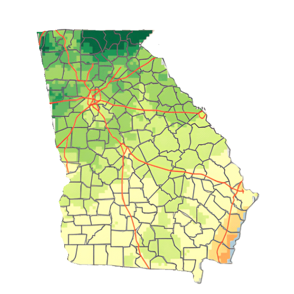
Temperature Projections: Drawdown Georgia Climate Outlook Maps
This section includes maps depicting the outlook for the Projected Number of Days Over 100°F, Projected Number of Days Over 105°F, Projected Number of Hot, Humid Nights, and Projected Number of Frost Days.
Each four-map set compares current conditions with projected conditions in 2050 under three potential emissions pathways:
- Moderate climate action, a middle-of-the-road scenario dependent on a somewhat higher level of climate action than is currently in place.
- Limited climate action, a scenario reflecting continued reliance on fossil fuels and rising emissions through the end of this century.
- Increased fossil fuel use and no efforts to reduce GHG emissions.
- These projections are based on climate modeling and represent plausible 2050 scenarios—not guaranteed outcomes.
These projections are based on climate modeling and represent plausible 2050 scenarios—not guaranteed outcomes.
Hot Days With Temperatures Over 100°F
Projected Number of Days Each Year with Highs Above 100°F in Georgia
The number of days over 100°F each year is an important factor that affects public health, energy demand, infrastructure durability, and agricultural productivity.
What This May Mean for Resilience Planning
- Higher peak electricity demand during summer
- Increased stress on roads, rail, and utility systems
- Expanded need for heat response strategies
- Greater irrigation and crop management considerations
Comparing the four maps helps us assess how extreme heat exposure could evolve by mid-century under different emissions pathways.
To pull these maps into a presentation, we recommend taking a screenshot. You can also download a PDF version here.
Very Hot Days With Temperatures Over 105°F
Projected Number of Days Each Year with Highs Above 105°F in Georgia
This map set shows how the number of very hot days (over 105°F) may change by 2050 under different emissions scenarios.
Very hot days are closely linked to heat-related illness, worker safety risks, livestock stress, and peak energy demand.
What This May Mean for Resilience Planning
- Heat emergency preparedness and cooling center access
- Outdoor worker protection policies
- Energy grid reliability during heatwaves
- Urban tree canopy and shade planning
These maps support decisions about how communities prepare for high-intensity heat events.
To pull these maps into a presentation, we recommend taking a screenshot. You can also download a PDF version here.
Humid Nights with High Overnight Heat
Projected Number of Hot, Humid Nights in Georgia
This four-map set compares the current number of nights with unusually warm temperatures to 2050 projections across three emissions pathways.
Persistent overnight heat limits recovery from daytime heat, worsens public health outcomes, increases cooling demand, and elevates livestock stress.
What This May Mean for Resilience Planning
- Public health monitoring during prolonged heat events
- Residential cooling needs and housing resilience
- Livestock and agricultural management strategies
- Energy demand forecasting
Planning for extreme heat should consider both daytime highs and overnight conditions.
To pull these maps into a presentation, we recommend taking a screenshot. You can also download a PDF version here.
Number of Days With Frost
Projected Number of Days When Overnight Lows Will Dip Below Freezing
Frost typically occurs when temperatures drop low enough to damage sensitive plants and crops. Changes in the number of days with frost can affect agriculture, ecosystems, and seasonal planning.
What This May Mean for Resilience Planning
- Shifts in planting and harvesting schedules
- Changes in crop suitability and pest dynamics
- Altered chilling hours for fruit and nut crops
- Impacts on native vegetation and forest health
Fewer frost days may extend the growing season in some regions, but they can also influence pest pressure, crop viability, and ecosystem balance.
Comparing current conditions with 2050 scenarios helps agricultural leaders and land managers assess how seasonal patterns may evolve under different emissions pathways.
To pull these maps into a presentation, we recommend taking a screenshot. You can also download a PDF version here.
Rainfall Projections: Drawdown Georgia Climate Outlook Maps
This section includes maps depicting the outlook for the Projected Number of Heavy Rainfall Events and Projected Dry Spells.
Each of the following sets of four maps compares current conditions with projected conditions in 2050 under three emissions pathways:
- Moderate climate action, a middle-of-the-road scenario dependent on a somewhat higher level of climate action than is currently in place.
- Limited climate action, a scenario reflecting continued reliance on fossil fuels and rising emissions through the end of this century.
- Increased fossil fuel use and no efforts to reduce GHG emissions.
These projections are based on climate models that represent plausible 2050 scenarios—not guaranteed outcomes.
Days With Rainfall Over 3 Inches
Projected Heavy Rainfall Events in Georgia
This map set compares current rainfall patterns with modeled 2050 projections of days with precipitation exceeding 3 inches.
Heavy rainfall events can strain drainage systems, increase flood risk, and disrupt transportation networks. These projections illustrate how precipitation intensity may shift under different emissions pathways.
What This May Mean for Resilience Planning
- Stormwater system design and upgrades
- Floodplain management
- Road, bridge, and culvert resilience
- Emergency response coordination
Viewing current conditions alongside 2050 scenarios can help planners evaluate whether infrastructure capacity aligns with projected rainfall trends.
To pull these maps into a presentation, we recommend taking a screenshot. You can also download a PDF version here.
Consecutive Days Without Rainfall
Projected Dry Spells in Georgia
This map set shows current patterns and projected 2050 changes in consecutive days without rainfall under moderate action, limited action, and increased fossil fuel use scenarios.
Extended dry periods are relevant for drought risk, agricultural productivity, wildfire planning, and water supply management.
What This May Mean for Resilience Planning
- Irrigation investment and efficiency strategies
- Long-term water storage planning
- Crop diversification and soil management
- Wildfire risk assessment
These projections provide a forward-looking view to inform water and land management strategies.
To pull these maps into a presentation, we recommend taking a screenshot. You can also download a PDF version here.
Growing Season Projections: Drawdown Georgia Climate Outlook Maps
These maps compare current conditions with projected conditions in 2050 under three emissions pathways:
- Moderate climate action, a middle-of-the-road scenario dependent on a somewhat higher level of climate action than is currently in place.
- Limited climate action, a scenario reflecting continued reliance on fossil fuels and rising emissions through the end of this century.
- Increased fossil fuel use and no efforts to reduce GHG emissions.
These projections are based on climate models that represent plausible 2050 scenarios—not guaranteed outcomes.
Growing Season Length
Projected Length of the Growing Season in Georgia
For this analysis, the growing season is defined as the number of days between:
- The first stretch of at least six consecutive days in a year when average daily temperatures rise above 41°F (5°C), and
- The first stretch after July 1 of at least six consecutive days when average daily temperatures drop below 41°F (5°C).
In simpler terms, it measures the span of the year when temperatures are consistently warm enough to support plant growth.
What This May Mean for Resilience Planning
- Shifts in planting and harvesting timelines
- Potential expansion or contraction of suitable crop varieties
- Increased irrigation needs during longer warm periods
- Changes in pest and disease cycles
- Implications for forestry management and habitat planning
A longer growing season may create both opportunities and challenges. By comparing current conditions with projected 2050 scenarios, agricultural producers, land managers, and policymakers can better assess how seasonal patterns may evolve under different emissions pathways.
To pull these maps into a presentation, we recommend taking a screenshot. You can also download a PDF version here.
How to Use the Drawdown Georgia Climate Outlook Maps


How Georgia Policymakers Can Use the Climate Outlook Maps
State, county, and municipal leaders regularly make long-term decisions about infrastructure, land use, public safety, and economic development. The Drawdown Georgia Climate Outlook Maps provide scenario-based projections that can inform those discussions.
For Resilience Planning
- Incorporate projected heat and rainfall trends into comprehensive plans
- Support hazard mitigation and emergency preparedness strategies
- Evaluate stormwater, drainage, and transportation infrastructure capacity
- Inform capital improvement timelines and long-term budgeting
- Assess potential stress on energy, water, and public health systems
By comparing current conditions with 2050 projections under multiple emissions pathways, policymakers can better evaluate how infrastructure investments align with potential mid-century climate conditions.
For Climate & Resiliency Communications
- Use side-by-side maps to explain how emissions trajectories may influence future heat or rainfall patterns
- Provide constituents with clear, visual context for investments in climate solutions and resilience planning
- Ground public meetings and workshops in Georgia-specific data
- Support grant applications or funding proposals with locally relevant projections
These maps can help leaders communicate why both resilience planning and emissions reduction strategies are relevant to long-term community stability.
How Georgia Farmers and Agricultural Leaders Can Use the Climate Outlook Maps
Georgia’s agricultural sector depends on anticipating changes in temperature and rainfall patterns. These projections provide a forward-looking lens for evaluating potential mid-century growing conditions.
For Resilience Planning
- Assess projected increases in extreme heat days and tropical nights
- Evaluate irrigation needs under longer dry spells
- Consider crop selection and diversification strategies
- Inform soil management and water storage planning
- Incorporate drought and rainfall variability projections into risk management
Comparing emissions pathways may help agricultural leaders understand how long-term heat exposure or rainfall variability could differ under alternative climate trajectories.
For Climate & Resiliency Communications
- Share projections in extension workshops or producer meetings
- Illustrate how emissions pathways may influence agricultural risk and the value of climate action for farmers
- Support conversations about climate smart agriculture, on-farm solar, and other climate solutions
- Provide data-driven context when discussing adaptation investments
The maps can serve as a compelling visual reference point for discussing both adaptation and emissions reduction in the agricultural community.
How Georgia Businesses Can Use the Climate Outlook Maps
Businesses with physical assets, supply chains, or workforce exposure in Georgia can use these projections to evaluate operational resilience and long-term planning assumptions.
For Resilience Planning
- Assess facility exposure to extreme heat or heavy rainfall
- Inform long-term capital planning and infrastructure upgrades
- Evaluate potential impacts on energy demand and cooling costs
- Incorporate projected climate conditions into enterprise risk assessments
- Consider workforce safety policies in high-heat environments
The 2050 projections offer scenario-based insights that can support asset management and risk mitigation strategies.
For Climate & Resiliency Communications
- Use comparative maps to explain why emissions reduction aligns with long-term operational resilience
- Support ESG reporting with Georgia-specific climate projections
- Provide stakeholders with visual evidence of potential mid-century trends
- Connect climate strategy discussions to physical risk considerations
By illustrating how emissions pathways may influence future climate conditions, the maps can support informed conversations about long-term value creation and risk management.
How Georgia Community Leaders and Advocates Can Use the Climate Outlook Maps
These maps provide a Georgia-specific foundation for community leaders to guide discussions and communications about local well-being, public health, and stewardship.
For Resilience Planning
- Facilitate workshops on local preparedness for extreme heat or heavy rainfall
- Identify neighborhoods that may be more exposed to high heat or flood risks
- Support conversations about cooling access, housing resilience, and water management
- Inform community-based preparedness strategies and mutual aid planning
The maps can help ground local resilience efforts in data that reflects Georgia’s projected mid-century climate conditions.
For Climate & Resiliency Communications
- Use side-by-side scenario maps to illustrate how emissions pathways may influence future heat and rainfall patterns
- Provide visual, Georgia-specific evidence when advocating for resilience investments or emissions reduction strategies
- Strengthen public comments, community forums, and stakeholder meetings with locally relevant projections
- Help build coalitions around shared goals such as protecting public health, safeguarding infrastructure, or supporting climate-smart land management
- Frame climate action as a long-term stewardship and community stability issue, supported by data rather than abstract statistics
By presenting clear comparisons between current conditions and modeled 2050 scenarios, the maps offer a practical tool for climate advocacy that is grounded in research and focused on local outcomes.
How Healthcare and Public Health Professionals Can Use the Climate Outlook Maps
Healthcare systems and public health agencies are on the front lines of extreme heat, flooding, and climate-sensitive health impacts. These maps provide Georgia-specific projections that can inform preparedness planning and community health strategies.
For Resilience Planning
- Assess projected increases in extreme heat and tropical nights to inform heat response planning
- Identify regions that may face higher exposure to prolonged high temperatures
- Support hospital and clinic preparedness for heat-related illness surges
- Inform emergency response coordination during heavy rainfall and flood events
- Integrate projected climate trends into community health assessments and public health planning
By comparing current conditions with modeled 2050 projections, public health leaders can better anticipate potential shifts in climate-related health risks and adjust preparedness strategies accordingly.
For Climate & Resiliency Communications
- Use side-by-side scenario maps to explain how emissions pathways may influence future heat exposure trends
- Provide data-informed context when discussing heat-related illness, vulnerable populations, and health equity
- Support public education campaigns about heat preparedness and community resilience
- Strengthen collaboration with local governments on infrastructure and cooling access investments
- Communicate the connection between climate resilience and long-term public health protection
The maps offer a clear, visual way to connect climate projections to health outcomes—helping healthcare leaders frame resilience planning and emissions reduction as part of a broader strategy to protect community well-being.
Learn More About the Drawdown Georgia Climate Outlook Maps
Find the answers to frequently asked questions about the Drawdown Georgia Climate Outlook Maps here.
Are the Drawdown Georgia Climate Outlook Maps predictions?
These maps are based on scientifically-informed, established climate modeling and show projected scenarios, not guaranteed outcomes. They illustrate how temperature and rainfall patterns may change by 2050 under different emissions pathways.
Climate models cannot predict exact conditions for a specific day or year. Instead, they provide data-driven, scenario-based estimates that help planners understand plausible mid-century trends.
These projections inform resilience planning and long-term decision-making, not to forecast specific weather events.
How reliable are these projections?
Climate projections are grounded in global climate models that simulate how the atmosphere, oceans, and land systems respond to different greenhouse gas emissions pathways. While uncertainty is inherent in any long-term modeling effort, these tools are widely used by governments, researchers, and infrastructure planners worldwide.
The maps should be viewed as decision-support tools that help communities explore potential future conditions under different scenarios.
How were the Climate Outlook maps developed?
Each set of maps is based on a Shared Socioeconomic Pathway (SSP) — a standardized set of global climate scenarios developed by the Intergovernmental Panel on Climate Change (IPCC). Shared Socioeconomic Pathways describe different ways the world’s population, economy, technology, and energy systems might evolve over time — and how those choices affect greenhouse gas emissions.
The Georgia Climate Outlook Maps compare four modeled conditions:
Present Day
The “current” map shows modeled climate conditions in the mid-2020s. These values are not direct measurements, but the result of climate models calibrated using historical data from 1950–2014 and extended forward through modeling techniques.
Moderate Climate Action (SSP2-45)
This scenario reflects a world that makes steady, moderate progress in reducing emissions. Global emissions peak around mid-century and decline significantly by 2100. It is often described as a “middle-of-the-road” pathway; not the most aggressive climate action, but not the worst case either. Under this pathway, warming continues but is more limited than under higher-emissions scenarios.
Limited Climate Action (SSP3-70)
This scenario reflects a more fragmented world with weaker international cooperation and slower emissions reductions. Emissions continue rising through much of the century, leading to higher overall warming by 2100. It is sometimes described as a “regional rivalry” pathway, where climate policy is inconsistent and fossil fuels remain dominant.
Increased Fossil Fuel Use (SSP5-85)
This is a worst-case scenario that assumes rapid economic growth powered largely by fossil fuels, with little meaningful climate mitigation. Emissions continue rising steeply, resulting in the highest levels of projected warming by the end of the century. SSP5, also known as “Taking the Highway,” is based on high economic growth driven by fossil fuel use increasing even beyond the current upward trendline.
Where does the data come from?
The maps are based on a dataset developed by Dr. Jay Alder of the U.S. Geological Survey. The dataset includes 40+ output variables for 27 global climate models, 16 of which were used for the Fifth National Climate Assessment (NCA5). Dr. Alder compiled a weighted average of the 16 models adopted for the NCA5, with weights used by the NCA5.
The input to the Alder datasets was the LOCA2 data created by Dr. David Pierce (and colleagues) of the Scripps Institution of Oceanography. Dr. Pierce’s team began with output from 27 global climate models with varying original resolutions and downscaled them to consistent grid cells of 1/16 of a degree.
What time period do these projections cover?
The maps compare current conditions with projected conditions for 2050 under three emissions pathways:
- Moderate climate action
- Limited climate action
- Increased fossil fuel use
Mid-century projections are particularly useful for infrastructure planning, agricultural strategy, and long-term capital investments.
Why do climate impacts vary across Georgia?
Climate impacts are not uniform because Georgia has diverse geography, including coastal areas, urban centers, farmland, and forested regions. Differences in elevation, land cover, proximity to the coast, and regional weather patterns influence how temperature and rainfall trends may shift.
That is why Georgia-specific projections are important. Localized climate modeling provides more relevant insight than national averages.
What are the main climate impacts projected for Georgia?
In the Southeastern U.S., we expect to see an increase in extreme heat, intensifying heavy rainfall and flooding risk, and coastal impacts from sea level rise and storm surge.
The region also faces changing water availability, growing challenges for agriculture and food systems, and health impacts tied to heat, disasters, air and water quality, and climate-sensitive diseases.
Is Georgia getting hotter?
Observed data shows warming trends over time, and climate projections indicate that very hot days are likely to increase by 2050 under higher emissions pathways. The maps on this page allow users to compare projected heat exposure under different scenarios.
Will Georgia experience more flooding in the future?
Heavy rainfall events are projected to change under different emissions pathways. The maps on this page illustrate how days with intense precipitation may shift by 2050, which can inform flood risk and stormwater planning discussions.
What is the difference between climate projections and weather forecasts?
Weather forecasts predict short-term atmospheric conditions over days or weeks. Climate projections estimate long-term trends over decades based on emissions scenarios and climate modeling.
The Drawdown Georgia Climate Outlook Maps focus on long-term projections to support resilience planning.
Can these maps be downloaded?
Yes, you can download PDFs of the Drawdown Georgia Climate Outlook Maps here.
These printable maps can be used in public meetings, grant applications, planning documents, or educational settings. You can also take screenshots of each map set to use in presentations.
What climate solutions are best for Georgia?
Drawdown Georgia’s research identifies 20 high-impact climate solutions tailored to Georgia’s economy, geography, and energy landscape. These include:
- Large-scale and rooftop solar
- Electric vehicles
- Building retrofits
- Reduced food waste
- Climate-smart agriculture
- Forest protection and tree planting
Visit the Drawdown Georgia Solutions Tracker to explore how these solutions are being scaled across the state.
How can I track greenhouse gas emissions in Georgia?
Drawdown Georgia’s GHG Emissions Trackers provide monthly emissions estimates at the state, county, and city level in Georgia.
These tools allow policymakers, researchers, and residents to:
- Track emissions trends over time
- Compare emissions across regions
- Monitor progress toward emissions reduction goals
You can also subscribe to Drawdown Georgia by the Numbers to receive quarterly emissions updates for your county.
How can I track progress on climate solutions in Georgia?
The Drawdown Georgia Solutions Tracker is a free, interactive tool that provides data on how the state is scaling climate solutions across sectors.
This tool helps users:
- Monitor adoption trends
- Understand which solutions are growing
- Identify opportunities for further progress
The Solutions Tracker provides county-level data and interactive maps so users can see where solutions like large-scale solar, EV charging infrastructure, energy efficiency upgrades, recycling, and composting are gaining traction, and where opportunities remain.
How can I stay up to date on climate news in Georgia?
Subscribe to the Georgia Climate Digest to receive updates on:
- Climate research
- New tools and resources from Drawdown Georgia
- Events for the Georgia climate community
- The latest news about climate solutions being implemented across the state